The Brazilian Amazon is facing a severe crisis due to deforestation and the degradation of its biodiversity. In an effort to understand and conserve this vital ecosystem, scientists have recently published a groundbreaking map that shows the above-ground biomass in the region. This new map, created using advanced technologies and innovative methodologies, provides crucial information for decision-making regarding planning, conservation, and sustainable management of the Amazon rainforest.
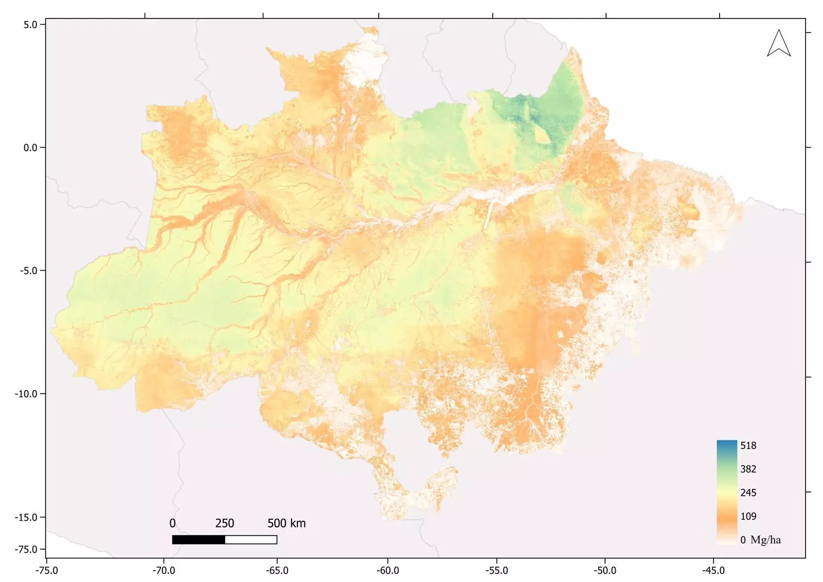
The study conducted the largest survey of tropical forest biomass ever conducted in the world. Utilizing a combination of airborne laser scanning, satellite imagery, field forest inventories, and machine learning, the researchers were able to create a comprehensive map of the Amazon’s biomass. Covering an area of 3,600 square kilometers, the map revealed an average of 174 metric tons of biomass per hectare, with a maximum of 518 tons per hectare. These figures highlight the immense biomass diversity present in the region.
To gather the necessary data for the mapping project, the researchers deployed advanced technologies, including airborne laser scanning and satellite sensors. A LIDAR sensor on board a low-flying Cessna aircraft emitted eight laser pulses per square meter on average, capturing precise measurements of tree diameter, height, and wood density. This technological breakthrough allowed for detailed estimation of above-ground biomass in kilograms.
To ensure accuracy, the researchers integrated data from various sources, including an instrument called PALSAR on the ALOS satellite, vegetation indices obtained from the MODIS sensor, and precipitation data from the TRMM mission. By combining these datasets with the transect surveys, they were able to extrapolate the biomass estimations for the entire Amazon region. The final calculations showed that the standing forest biomass amounts to approximately 75 billion tons.
The mapping of the Amazon’s biomass is of particular significance in the context of climate change. With the increasing risk of the Amazon transitioning from a carbon sink to a net emitter of carbon, it is crucial to understand the current state of its biomass. The new map provides scientists with valuable information to assess whether biomass is being gained or lost over time. This data is essential for predicting the impact of deforestation and degradation on carbon dioxide emissions in the region.
The map serves as a vital tool for decision-making in the face of the Amazon’s environmental challenges. It provides key information for planning conservation initiatives and sustainable management practices. By understanding the distribution and density of biomass in different areas, policymakers and conservationists can develop targeted strategies to protect and restore the rainforest. The map also highlights the need to prioritize the conservation of areas with high biomass, as they are likely crucial for maintaining the Amazon’s ecosystem services.
The survey conducted in the process of mapping the biomass also led to several fascinating discoveries. The presence of pre-Columbian geoglyphs indicates that the Amazon was once densely populated, challenging previous notions of its historical human occupation. Furthermore, the study confirmed that the tallest tree in the Amazon rainforest is the magnificent Dinizia excelsa, reaching a height of 88.5 meters above the forest floor. These findings further emphasize the ecological significance and unique characteristics of the Amazon rainforest.
The publication of the new biomass map of the Brazilian Amazon represents a milestone in our understanding of this crucial ecosystem. Through advanced technologies and innovative integration of data, scientists were able to create a detailed assessment of the above-ground biomass in the region. This map provides essential information for decision-making regarding the conservation and sustainable management of the Amazon rainforest. Furthermore, the study’s findings shed light on the historical human occupation of the region and the unique natural wonders that exist within its boundaries. With this newfound knowledge, we have an opportunity to take action and protect this invaluable natural treasure for generations to come.
Leave a Reply