Farmland has become a battleground in the ongoing fight against climate change. With the competing interests of solar panels, energy crops, and food production, policy choices can often lead to the release of more heat-trapping gases into the atmosphere. Strategies for sustainable plant-based fuels have been focusing on marginal lands in order to address this issue. A recent tool developed by scientists at the University of Wisconsin-Madison demonstrates a promising solution to this dilemma by mapping abandoned cropland in the United States using machine learning technology. This mapping provides the groundwork for decisions on how to best utilize these lands to balance energy and food production.
The Importance of Abandoned Croplands
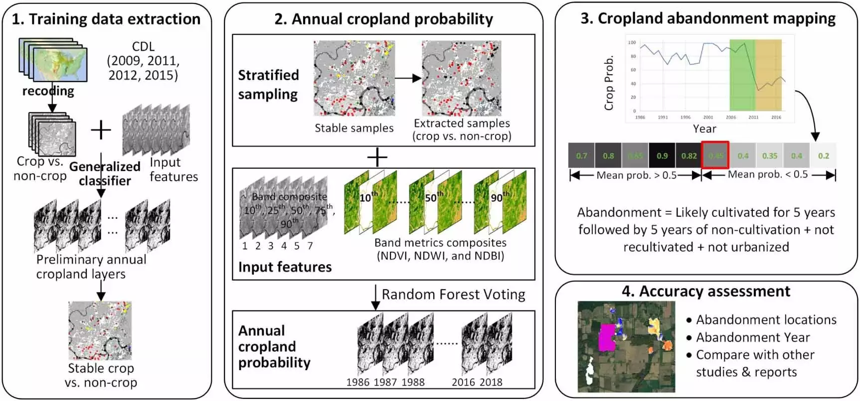
Led by Yanhua Xie and Tyler Lark from the Great Lakes Bioenergy Research Center, this research team conducted an in-depth analysis of nearly 30 million acres of previously cultivated land abandoned since the 1980s. Utilizing detailed mapping techniques, they identified ideal locations for growing alternative crops like switchgrass and sorghum, which have the potential to trap carbon in the soil and serve as valuable biofuel feedstocks. By understanding the characteristics of these abandoned lands, researchers can assess their viability for climate mitigation efforts. This data-driven approach allows for targeted investment in clean energy projects with minimal interference in other beneficial land uses.
Traditional sources of data, such as the USDA’s Census of Agriculture, have provided valuable insights into farmland distribution but lacked the specificity needed to pinpoint abandoned croplands. Through advancements in cloud computing and satellite imagery analysis, the research team was able to achieve unparalleled resolution in mapping these lands. By training a computer algorithm to recognize cultivation patterns in satellite data spanning over three decades, the researchers accurately identified abandoned cropland locations with a high degree of precision. This level of analysis allows for a deeper understanding of land use changes and the potential for repurposing these lands for sustainable practices.
The results of the study revealed that over 30 million acres of cropland had been abandoned in the United States over the past 32 years, particularly concentrated in the Great Plains and along the Mississippi River. Surprisingly, less than a fifth of this abandoned land was enrolled in formal conservation programs, indicating a vast potential for cultivating bioenergy crops. With the ability to model biomass growth and carbon sequestration on these lands, researchers can better assess their sustainability and environmental impact. The next phase of the study will focus on identifying the drivers behind land abandonment, using socioeconomic and tax data to inform future land use decisions.
As we navigate the challenges of climate change and agricultural sustainability, the utilization of abandoned croplands for sustainable plant-based fuels offers a promising solution. By leveraging cutting-edge technology and data analysis, researchers can identify optimal locations for cultivating bioenergy crops while minimizing competition with food production. The insights gained from this study pave the way for informed decision-making in clean energy investments and land use management. As we continue to explore the potential of abandoned farmland, we move closer to achieving a harmonious balance between food production and environmental conservation in the face of climate change.
Leave a Reply