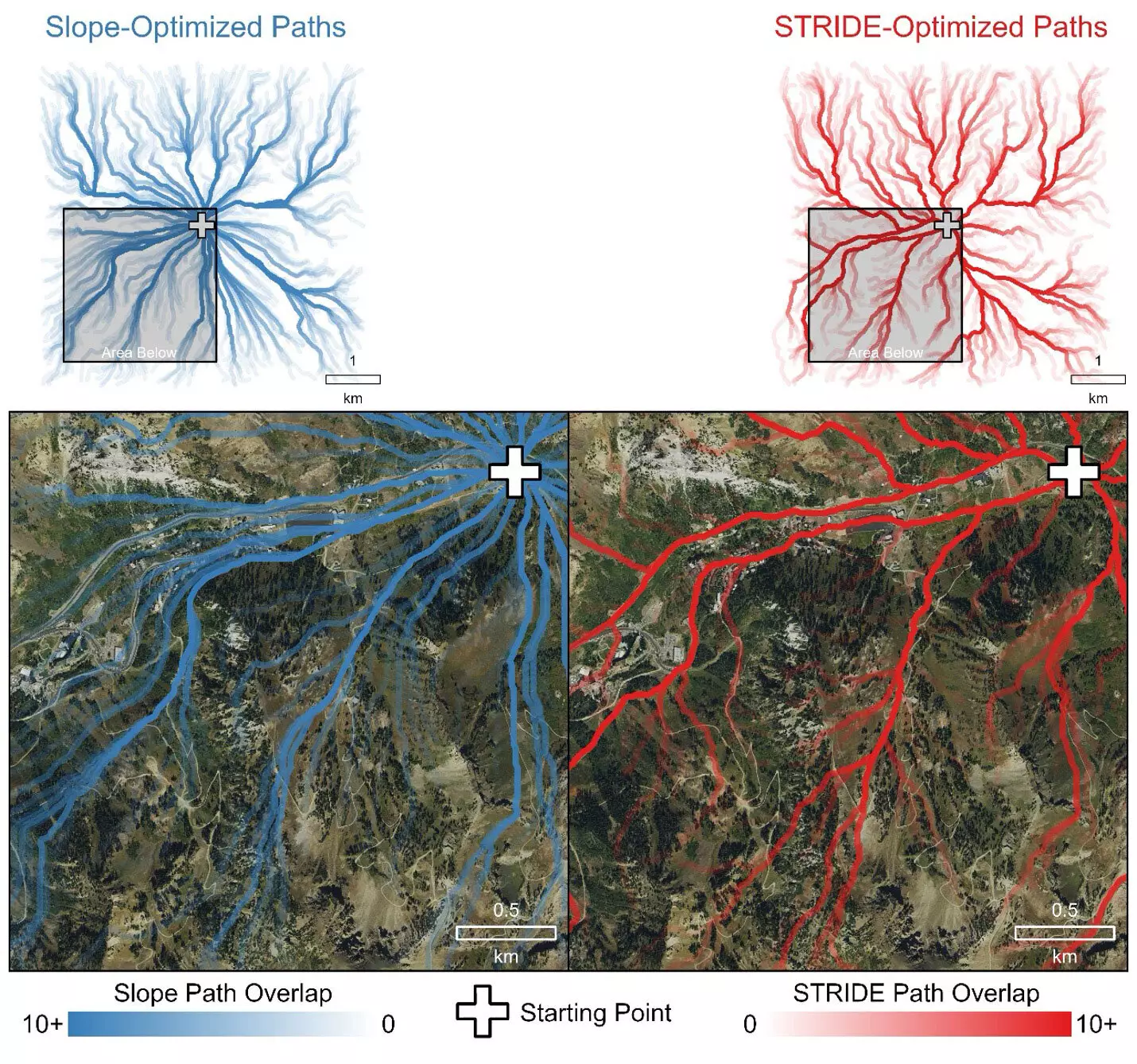
In the battle against wildfires, effective evacuation strategies are crucial for the safety of firefighters and first responders. When a fire unexpectedly jumps its containment lines, every second can be the difference between life and death. In such high-pressure situations, firefighters must navigate through challenging terrains while relying heavily on their experience and collective knowledge. Unfortunately, traditional mapping methods have proven inadequate, relying primarily on the steepness of the landscape as the primary factor in estimating travel times. This reliance on simplistic terrain models often leads to inaccurate perceptions of how long it will take to reach safety, ultimately jeopardizing the well-being of those on the ground.
Fortunately, researchers at the University of Utah have recently unveiled an innovative approach to improving the modeling of evacuation routes for wildland firefighters. Dubbed the Simulating Travel Rates in Diverse Environments (STRIDE) model, this revolutionary tool integrates various factors influencing travel time such as ground roughness and vegetation density, alongside slope steepness. By factoring in these critical elements, STRIDE stands to revolutionize how firefighters and other professionals assess movement across diverse terrains, thereby enhancing safety during emergencies.
STRIDE is lauded for being the first comprehensive model to utilize airborne Light Detection and Ranging (LiDAR) data in determining efficient evacuation paths. LiDAR technology captures minute details about the terrain and vegetation by bouncing millions of laser pulses off the ground. This creates highly accurate three-dimensional maps that indicate not just the elevation but also the density of vegetation and the roughness of the surface. The team’s integration of this advanced technology promises a more realistic portrayal of the landscapes that firefighters must traverse, enriching their decision-making capabilities in urgent scenarios.
What makes STRIDE particularly compelling is its foundation in real-world testing. The researchers conducted extensive field trials, where volunteers traversed diverse landscapes mapped by LiDAR. By measuring how long it took various individuals to walk designated transects, the researchers captured a range of human performance metrics, thereby enriching the model with invaluable experiential data. This rigorous testing phase ensured that STRIDE could predict travel rates across not only wild, unmarked terrains but also urban settings, greatly expanding its applicability in emergency scenarios.
The data-driven approach of STRIDE could have terrifying implications for firefighter safety. History has shown that inadequate evacuation planning can lead to catastrophic outcomes, as witnessed during the tragic Yarnell Hill fire in 2013. The introduction of STRIDE provides a robust framework to analyze mobility in perilous conditions more accurately. By enabling firefighters to select safer and more efficient evacuation routes, the tool aims to reduce response times when every moment counts. STRIDE is poised to be a game-changer in the fight for firefighter well-being, opening avenues for better training and preparedness.
The benefits of STRIDE don’t just stop with firefighting. Its design allows it to be an essential resource for various professionals— from disaster responders to archaeologists and outdoor recreation planners. By understanding how terrain affects mobility, STRIDE can assist in mission planning and response strategies across many fields. The adaptability of the model showcases its potential in times of crisis, thus making it a crucial asset in improving overall public safety and operational efficiency.
The research team behind STRIDE is actively engaged in making their findings and tools accessible to the wider public. By publicly releasing the model, they aim to equip all professionals with the ability to leverage LiDAR data in pursuit of safer and more efficient travel across various environments. As organizations like the U.S. Forest Service endorse the research, the prospect of using STRIDE to update evacuation protocols and ground evacuation time estimations could lead to systematic improvements in wildfire readiness efforts.
In the landscape of emergency management, the STRIDE model exemplifies the intersection of technology and practical application. By marrying LiDAR data with rigorous field testing, this innovative tool promises to redefine how first responders navigate wildfires, ultimately prioritizing safety and efficacy in evacuation routes. As we continue to confront escalating wildfire risks, the insights gleaned from STRIDE might very well transform the future of emergency evacuation strategies, underscoring the importance of comprehensive and data-driven approaches in safeguarding lives.


Leave a Reply