When China’s Tianwen-1 mission arrived in orbit around Mars in July 2020, it marked the beginning of a new era in interplanetary exploration. The mission consists of a diverse set of robotic elements, including an orbiter, a lander, two deployable cameras, a remote camera, and the Zhurong rover. The primary goal of the mission is to delve into Mars’s geology, internal structure, atmosphere, and the search for signs of water on the red planet.
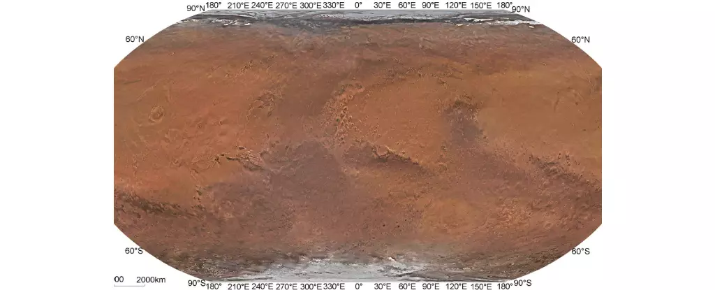
A team of researchers from the Chinese Academy of Sciences (CAS) played a pivotal role in the success of the Tianwen-1 mission. Led by Professor Li Chunlai and Professor Zhang Rongqiao, the team combined remote-sensing images captured by the Tianwen-1 orbiter to create the first high-resolution global color-image map of Mars. This map boasts spatial resolutions greater than 1 km (0.62 mi), making it the most detailed map of Mars to date.
While previous missions have also contributed to global maps of Mars using remote-sensing images, the CAS team’s map surpasses all previous efforts in terms of resolution and color accuracy. For example, the spatial resolution of the CAS team’s map far exceeds that of maps created using data from missions such as the Mars Global Surveyor (MGS), Mars Reconnaissance Orbiter (MRO), and Mars Odyssey orbiter.
The Tianwen-1 Mars map opens up a world of possibilities for future exploration and research on Mars. Its high resolution and color accuracy make it an invaluable resource for planning future missions to the red planet. The map could serve as a base map for crewed missions to Mars in the coming decades, providing crucial information for selecting landing sites and conducting scientific research.
As space agencies around the world gear up for crewed missions to Mars, the Tianwen-1 Mars map will play a crucial role in shaping the future of Mars exploration. By providing a detailed and accurate representation of the Martian surface, the map will guide scientists, engineers, and astronauts in their quest to unlock the mysteries of the red planet. With the launch of crewed missions on the horizon, the Tianwen-1 Mars map stands as a testament to humanity’s insatiable curiosity and unending quest for discovery.
The creation of the high-resolution global color-image map of Mars by the Tianwen-1 mission represents a significant milestone in the exploration of the red planet. This groundbreaking map, produced by the team of researchers from the Chinese Academy of Sciences, sets a new standard for Mars mapping technology and paves the way for future missions to Mars. As we look ahead to the dawn of crewed missions to Mars, the Tianwen-1 Mars map will undoubtedly shape the course of human exploration of the red planet for years to come.
Leave a Reply